Seven Islands of Bombay
The Beginning of Bombay’s History
On September 1, 1668, the ship ‘Constantinople Merchant’ landed on the coast of Surat. It brought a copy of the Royal Charter dated March 27, 1668. Which granted the English East India Company ownership of the Port and Island of Bombay “to be owned in common and free space. As part of the Manor of East Greenwich “for a yearly fee of 10 pounds, payable on September 30.
This event marked the beginning of Bombay’s history. Which is now one of India’s biggest metropolises and the nation’s financial center. In 1995, authorities renamed Bombay to Mumbai. Modern sources refer to the colonial city as Bombay in this article.

Source: Wikimedia Commons
The Transfer and Formal Cession of Bombay
In a letter dated March 27, 1668, the Directors of the Company in London notified their Surat-based factory workers about Bombay’s transfer.
They wrote to the Crown’s Governor in Bombay on the same day, requesting him to implement the transfer. On March 30, 1668, they announced that the President and Council in Surat would assume control of Bombay.
Upon receiving the charter, the Surat Council convened on September 3, 1668. And resolved to dispatch their Commissioners—Mr. Goodier, Capt. Henry Young, and Mr. Streynsham Masters—to assume control of the Islands.
The English officer arrived in Bombay following the three Inspectors did Capt. Henry Gary formally ceded the island, along with its live and dead stock, guns, ammunition, troops, and cash totaling 4879 pounds, 7 shillings, and 6 pence, on September 23, 1668. Sir George Oxenden, the president of the Surat Council, served as Bombay’s governor.
The Geography and Terrain of the Seven Islands
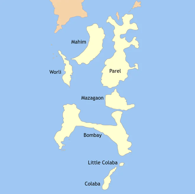
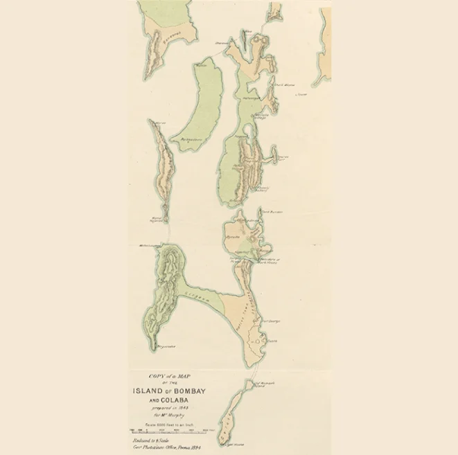
Bombay, Mazagaon, Parel, Worli, Mahim, Little Colaba (sometimes called the Old Woman’s Island). And Colaba is the seven islands that the Company purchased.
These islands feature diverse terrain, including salt pans, mangrove forests, tidal flats, and low hills. Three large openings or inlets between the islands allowed water to rush in during high tide, leaving behind swamps of salted water as the flood receded. At low tide, people could travel from Bombay to Mazagaon due to the shallow sea, while boats bridged the gap between other islands.
The Portuguese had controlled the islands since 1534. They used the islands primarily for agricultural purposes, constructing a few causeways to span the flats.
Source: Wikimedia Commons
Despite this, the English Company saw significant political and economic value in these islands.
In 1627, the English Companies even attempted an abortive takeover of the islands from the Portuguese with support from the Dutch East India Company.
Article 11 of the Treaty of Peace and Alliance between Portugal and Great Britain, concluded on June 23, 1661, and accompanying the marriage of King Charles II and Catherine of Braganza of Portugal, granted Bombay to the English Crown.
However, the Crown quickly sought to dispose of these islands, as the King neither valued them nor wanted to bear the cost of maintaining them.
The Strategic Importance of Bombay and Plans for Development
The Company eagerly sought to develop Bombay due to its excellent natural harbor, which could be used year-round for deep-sea navigation.
Furthermore, it could facilitate easy and direct connections with English industries in the Spice Islands (Maluku Islands), the Malabar Coast, and Persia. Additionally, it promised enhanced defense against competing European nations, Indian forces, and pirates.

Source: Wikimedia Commons
In 1671, Gerald Aungier, the governor of Bombay and President of the Surat Council, presented detailed plans for the city’s growth.
Upon receiving the Directors’ approval, officials took steps to fortify the island, construct docks, and establish institutions to cater to the city’s needs and justice system. The board was frequently urged by corporate personnel to move the business’s headquarters from Surat to Bombay.
The Development and Transformation of Bombay
The Company promoted immigration to expand Bombay’s population base, necessitating land for farming and habitation. This requirement led to the need to drain and reclaim land, contingent upon sealing the openings through which seawater entered.
Additionally, Bombay experienced a high mortality rate, with the average lifespan of an Englishman found to be just three years.
The primary culprit was malaria, which was caused by the saltwater wetlands left behind by the retreating tides. Closing the water inlets, clearing the wetlands, and reclaiming land from the sea became necessary as a result. These collective actions brought the seven islands together and formed an island city.
Source: Wikimedia Commons
Mapping Breach Candy: Engineer Herman Bake’s 1674 Survey
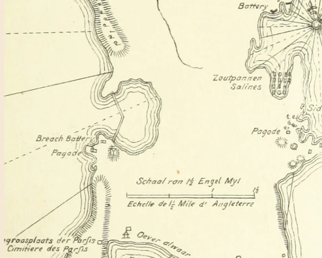
Governor Aungier hired Engineer Herman Bake in 1674 to create a map of the island, highlighting the areas affected by swamps and the inlets responsible for them.
The Surat Council notified the Directors of the three main breaches—between Worli and Mahim, Mahim and Parel, and the island of Bombay (Malabar Hill)—collectively known as Breach Candy. The Bombay administration dispatched Bake to personally present the map to the directors.
Initially, the Company’s directors hesitated to invest financial resources in reclamations, believing that private individuals could handle the task.
They outlined certain terms and conditions for leasing property for drainage, such as offering a 99-year lease with a nominal quit-rent payable to the corporation.
Alternatively, they allowed land to be rented out with the condition that reclamation work must be completed within seven years. As malaria deaths increased, it took the Directors an additional ten years to be convinced to construct dams and reclaim land.
Source: Wikimedia Commons
Efforts to Reclaim and Develop Bombay’s Submerged Territories
On April 7, 1684, they wrote, “Repair those submerged territories of Bombay,” and included specific instructions on how to proceed with the work in the same letter.
They directed the Company’s representatives in India to appoint undertakers responsible for constructing embankments and reclaiming the land.
The Company was to pay these undertakers every Saturday night for the labor of each worker they employed. Part of which was to be paid in rice and the rest in cash. Additionally, upon completion of the job, the undertakers were to receive a specified amount of money.
They recommended installing sluices in the dams to allow sea water to enter for salt production or to drain the land if it is used for agriculture, leaving the choice to the Indian firm.
They instructed using earth from higher ground areas to fill the flooded portions of the land along the seaside, leveling it with the sea.
Early Engineering and Administrative Developments in Bombay
The Directors instructed the Company to build sluices at a height sufficient to prevent sea water from returning when they opened to drain rainwater. They ordered the Company to relocate its headquarters to Bombay in 1685 And the directive took effect on May 2, 1687.
Around 1690, after extensive correspondence and deliberation. The Umarkhadi gap between the islands of Bombay and Mazagaon was closed as the first water entry. Mazagaon did not emerge as a distinct island until 1690–1.
Source: Wikimedia Commons
Under Nicolas Waite’s administration, the work progressed further. In 1704, Waite appointed William Aislabi to seal the northern inlets. To accomplish this, construction began on five embankments with sluices to drain water during low tide.
By March 1711, three of these embankments—two at the northern end of Parel and one between Parel and Mahim—had been completed.
Land Reclamation and Infrastructure Development in Bombay
By January 1712, they completed the embankment between Worli and Mahim, connecting the island of Mahim to Parel and Worli through these operations.
The closure of the inlets resulted in reclaimed land being leased to farmers known as Kunbis under the ‘Toka’ tenure system. Under this system, the landowner, the company, and the cultivator shared the produce, primarily rice.
The largest obstacle, however, was sealing the massive opening between Worli and Bombay. Known as the Breach Candy (the name “Candy” comes from the Marathi word “Khind,”. Meaning a gap in the granite ridge).
The Bombay Council approved a financial contribution of Rs. 20,000 for constructing an embankment to close the gap, as recommended by the company’s engineer, Mr. Bates.
Transformation and Growth: Bombay’s Infrastructure and Urban Development
Despite Bates’s initial estimate of nine months, the project that began in 1720 was not completed until 1728. Regular repairs became necessary because the wall was insufficiently sturdy to keep out saltwater.
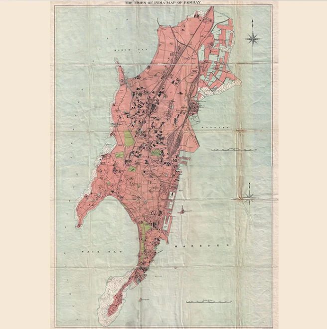
The Hornby Vellard, named after the Portuguese term “Vallado” (meaning fence), was only constructed during Governor William Hornby’s administration (1772–1784), and it was this that ultimately resolved the issue.
Source: Wikimedia Commons
This resulted in the reclamation, drainage, and leasing of around 400 acres of land for farming.
Along with inland expansion, the densely populated inner city witnessed the development of new residential zones such as Mahalaxmi, Kamathipura, Tardeo, and Bycullah.
Built to connect the east and west coastlines, the Bellasis Road causeway stretches from Malabar Hill to Mazagaon.
The authorities combined the final islands, Colaba and Little Colaba. Overcrowded boats caused accidents. In 1796, they designated Colaba as a cantonment area.
The Bombay Council’s suggestion to construct a causeway was accepted by the directors once they were convinced of its benefits. After completing construction in 1838, the Colaba Causeway connected the two islands to Bombay.
By 1838, they had accomplished the goal of uniting the seven islands. The resulting island metropolis is now known as South Bombay.
ALSO READ: Bharatanatyam तकनीक और प्रशिक्षण

