The 1968 Atlantic Ocean Floor Map by Bruce Heezen and Marie Tharp: A Revolution in Oceanography
In 1968, a groundbreaking map depicting the floor of the Atlantic Ocean was published, based on extensive ocean depth surveys compiled by pioneering geoscientists Bruce Heezen and Marie Tharp. This map was revolutionary in its level of detail and scientific significance, bringing to light features of the ocean floor that had long been hidden and misunderstood. The work of Heezen and Tharp fundamentally changed our knowledge of the oceanic crust and played a central role in the validation of the theory of plate tectonics.
The Visionaries Behind the Map: Bruce Heezen and Marie Tharp
Bruce Heezen was an oceanographer who collected critical bathymetric data on ocean depths through ship-based depth soundings, while Marie Tharp, a gifted cartographer and geologist, meticulously translated this data into detailed maps of the ocean floor. Working together from the early 1950s, their productivity was remarkable despite the challenges of the era, including restrictions on women working on research vessels, which initially prevented Tharp from participating directly in data collection trips. Instead, she worked on land to transform the raw sonar data collected by Heezen into visual maps that revealed the ocean floor’s topography.
The 1968 Map’s Contributions to Ocean Science
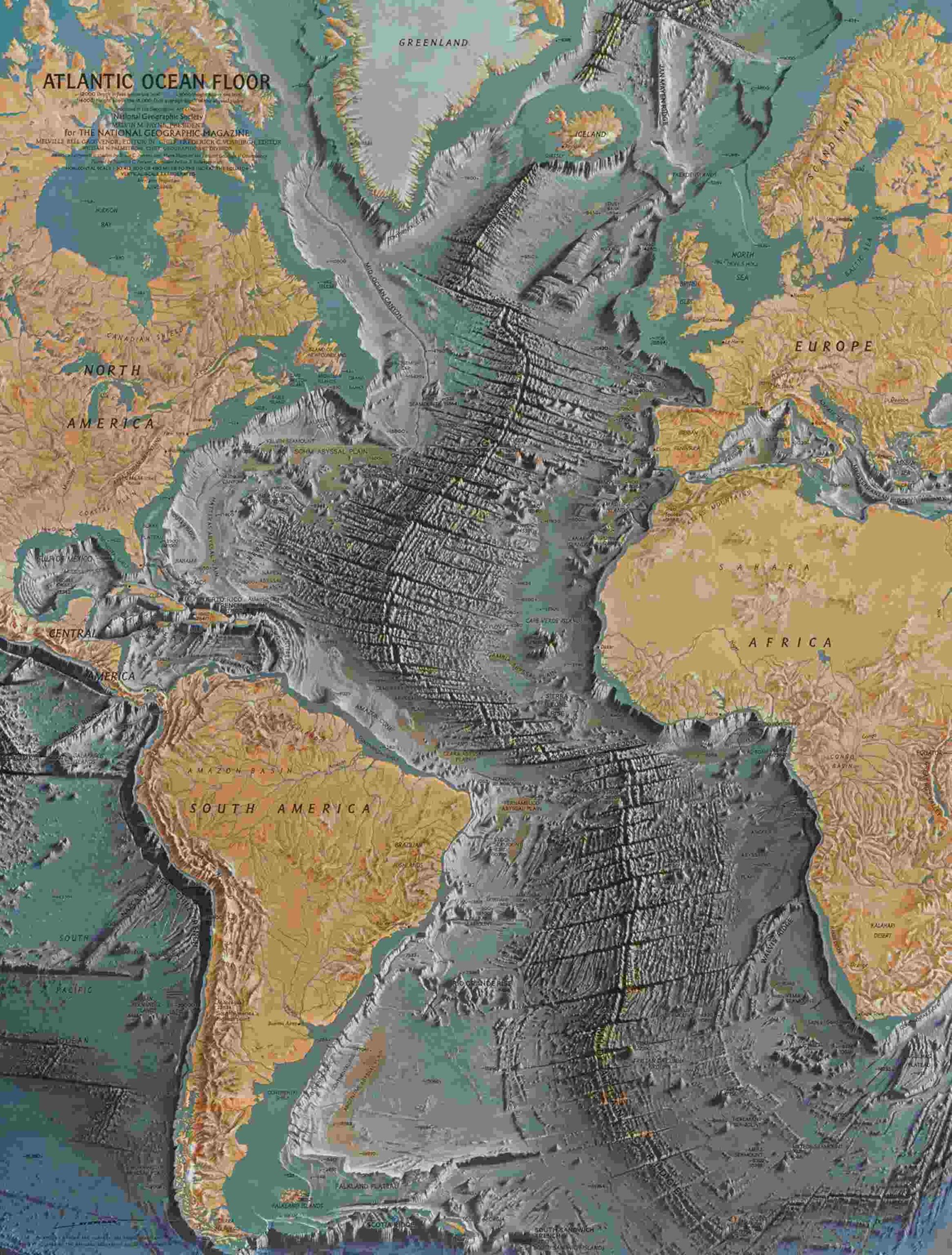
The 1968 map of the Atlantic Ocean floor was not only a cartographic triumph but also a scientific milestone. It depicted the seabed’s complex landscape, which included deep ocean trenches, canyons, mountain ranges under the sea, and most notably, the Mid-Atlantic Ridge—a massive underwater mountain chain running down the ocean’s center. This ridge was identified as a rift valley where two tectonic plates were diverging, creating new oceanic crust. This was the first time such detailed evidence of seafloor spreading was visually represented.
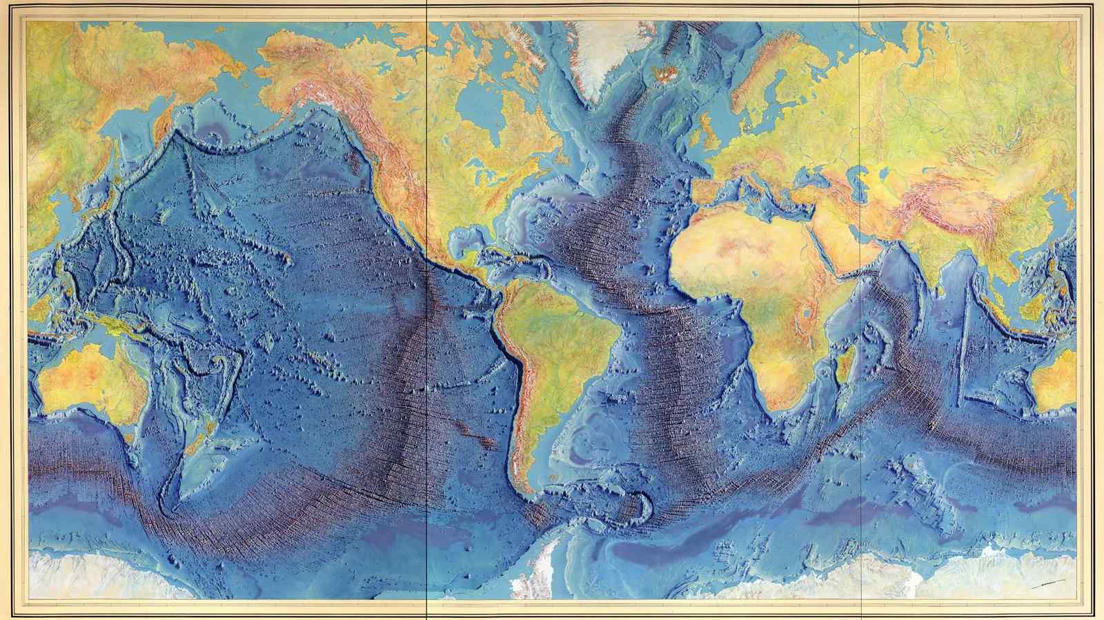
This map helped to substantiate Alfred Wegener’s controversial theory of continental drift, which had been widely dismissed for decades. By revealing the near-global presence of mid-ocean ridges and associated tectonic activity, Heezen and Tharp’s work contributed directly to the broader acceptance of the plate tectonics theory that explains the movement of Earth’s lithospheric plates.
Techniques and Challenges in Mapping the Ocean Floor
Creating the 1968 map required painstaking efforts. Using data from echo soundings performed aboard the research ship Vema and instruments like the echo sounder, ocean depths were measured as sound waves bounced off the seabed. Tharp then manually plotted this data to create a physiographic diagram—a map style that showed geological features as if viewed from above and slightly tilted, enhancing depth perception.
The map was further enhanced with seismic data, showing earthquake epicenters that corresponded to underwater geological faults and rift zones. Adding another layer of understanding to the ocean’s dynamic nature.
Impact of the Map on Modern Geology and Oceanography
This 1968 map marked a turning point in marine geology and geophysics. It influenced scientists to explore further the idea that the ocean floor was not static but continuously reshaped by geological forces. The map was a key piece of evidence leading to the widespread acceptance of seafloor spreading and plate tectonics. Concepts critical to explaining earthquakes, volcanic activity, and the formation of mountain ranges on continents.
Despite early skepticism—even from prominent figures like Jacques Cousteau. The evidence presented by Heezen and Tharp won over the scientific community. Their map became a foundational tool in oceanographic research and is recognized. For bridging the gap between raw data and theoretical geology, inspiring generations of earth scientists.
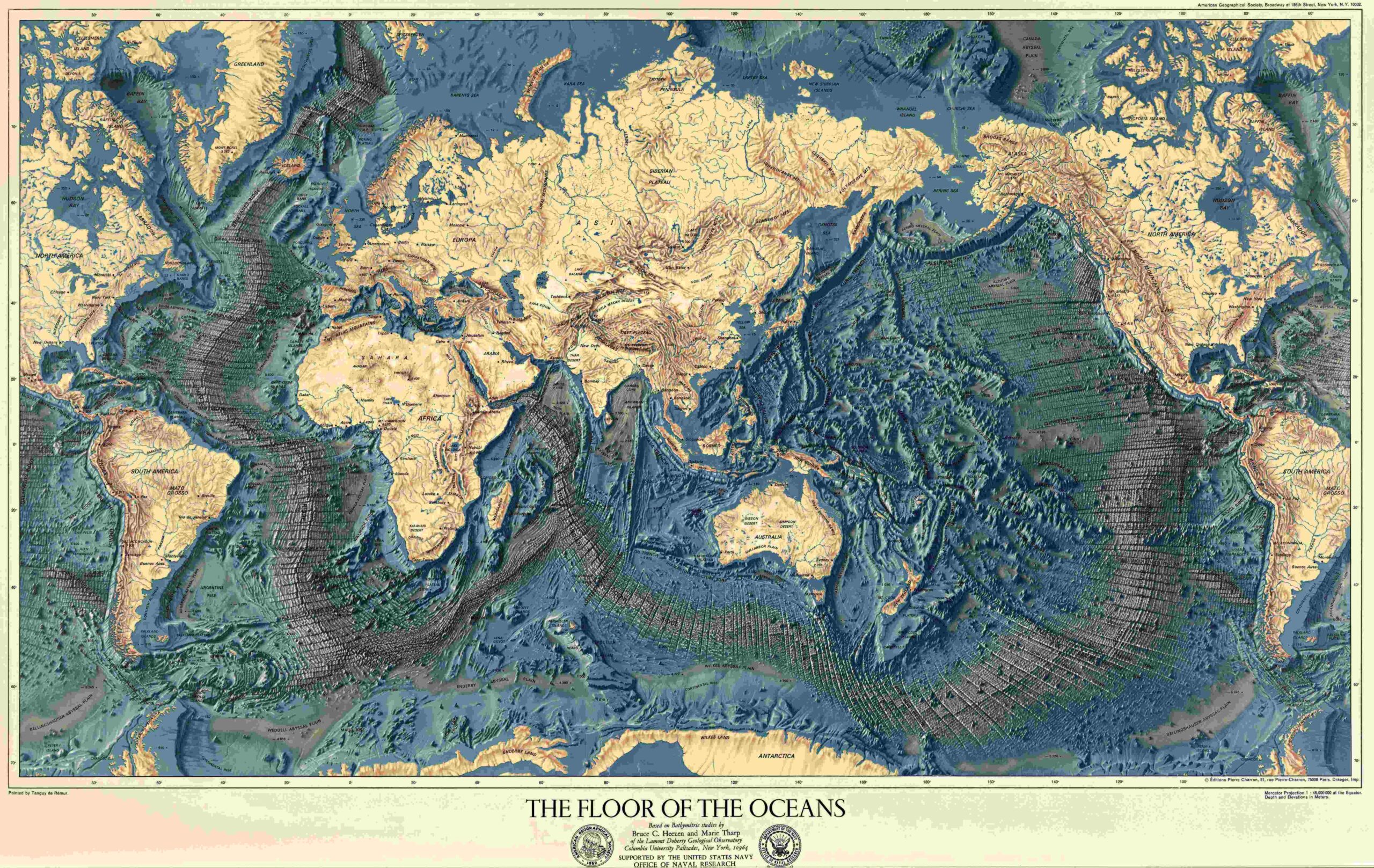
The Artistic Dimension: Collaboration with Heinrich Berann
In the years following the publication of maps like the 1968 Atlantic Ocean floor map. The team collaborated with renowned artist Heinrich Berann. To create even more visually stunning and scientifically accurate depictions of not just the Atlantic. But ocean floors worldwide. These panoramic physiographic maps combined scientific precision with compelling visualization. That communicated complex oceanographic data to both experts and the general public. Further popularizing the importance of ocean floor studies.
Legacy of the 1968 Atlantic Ocean Floor Map
The legacy of the 1968 Atlantic Ocean floor map endures in today’s oceanographic research and education. It symbolizes a leap forward in understanding the planet’s geology and the vital role oceans play in earth systems. The work of Heezen and Tharp remains a testament to the power of collaboration, meticulous data analysis, and visionary cartography. In revealing the hidden landscapes beneath the sea that shape our world.
This comprehensive exploration of the 1968 Atlantic Ocean floor map by Bruce Heezen and Marie Tharp. Showcases not only a scientific milestone. But also a story of dedication, innovation, and discovery that transformed earth sciences. Their pioneering work continues to influence oceanography, geology, and our understanding of the dynamic planet beneath the waves.
ALSO READ: The Minaret of Jam: A Tower of History in the Heart of Afghanistan